
FEMA and the County
092610
Fema gets more attention this time around!
By Liz Fisher
This time it really was standing room only...
082910
FEMA Meets with the County
photo and story by Liz Fisher

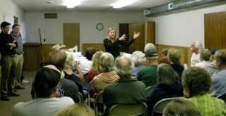
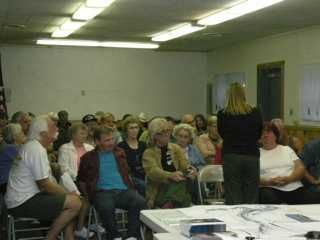
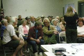
Downieville- A standing room only gathering of local residents met with FEMA representatives, Engineer Kathleen Schaefer, National Flood Insurance Program under the auspices of U.S. Department of Homeland Security and Technical Manager James Johnston of Michael Baker Jr., Inc.
Schaefer presented the new FEMA Flood Map showing pretty much all of Downieville in a flood zone, called Zone AE. Zone A means a potential flood zone. Zone AE means you are in an established flood zone and in the Downieville area that is any area below the elevation of 2,911 feet.
Unfortunately. as you look at the flood maps. it does not have the elevation as it exists in any location, only whether that is an area where if you are less than 2,911 feet you are in Flood Zone AE.
According to FEMA the 100-year flood is sort of nebulous as it is possible to have a 100-year flood each and every year. In April of 2011 the new map will be effective, until then FEMA is looking for comments and any concerns about a particular location. There is a website to look at the map. www.map-9.com/projects. A contractor called Map-9, which is a consortium of engineers, developed the map for FEMA Region 9, also known as us.
There is an area on the map lying outside of Downieville where two unnamed creeks flow that have been designated Zone A which changed a much larger land area, designated as Zone D. Flood Insurance can be required in Zone D so eliminating the Zone D and making it a Zone X (no insurance required) and just an area along the unnamed creeks as Zone A eliminates much of the required insurance area.
So how the Corp of Engineers used contour maps to establish the elevations of Downieville to determine where the elevation of 2,911’ is the magic number is unknown, as the actual elevations were not noted on the new flood maps.
What it means to us is if you have a federally back mortgage you must have flood insurance. FEMA will help you if there is a flood but if you don’t have insurance the maximum amount is $28,000 and with insurance there is a maximum of $250.000 for the building and $100,000 for the contents.
Schaefer encourages residents to go to the Sierra County Planning Department and talk to Brandon Pangman or Andrew Winberry and look at the new maps. She is also available for questions at 510 627-7129.
Fema gets more attention this time around!
By Liz Fisher

This time it really was standing room only...

FEMA reps field questions and allow residents to
review maps...

Is Steve sending a message and to who?
082910
FEMA Meets with the County
photo and story by Liz Fisher

FEMA Engineer Kathleen Schaefer, James Johnston,
Andrew Winberry and Brandon Pangman confer.
Andrew Winberry and Brandon Pangman confer.
Downieville- A standing room only gathering of local residents met with FEMA representatives, Engineer Kathleen Schaefer, National Flood Insurance Program under the auspices of U.S. Department of Homeland Security and Technical Manager James Johnston of Michael Baker Jr., Inc.
Schaefer presented the new FEMA Flood Map showing pretty much all of Downieville in a flood zone, called Zone AE. Zone A means a potential flood zone. Zone AE means you are in an established flood zone and in the Downieville area that is any area below the elevation of 2,911 feet.
Unfortunately. as you look at the flood maps. it does not have the elevation as it exists in any location, only whether that is an area where if you are less than 2,911 feet you are in Flood Zone AE.
According to FEMA the 100-year flood is sort of nebulous as it is possible to have a 100-year flood each and every year. In April of 2011 the new map will be effective, until then FEMA is looking for comments and any concerns about a particular location. There is a website to look at the map. www.map-9.com/projects. A contractor called Map-9, which is a consortium of engineers, developed the map for FEMA Region 9, also known as us.
There is an area on the map lying outside of Downieville where two unnamed creeks flow that have been designated Zone A which changed a much larger land area, designated as Zone D. Flood Insurance can be required in Zone D so eliminating the Zone D and making it a Zone X (no insurance required) and just an area along the unnamed creeks as Zone A eliminates much of the required insurance area.
So how the Corp of Engineers used contour maps to establish the elevations of Downieville to determine where the elevation of 2,911’ is the magic number is unknown, as the actual elevations were not noted on the new flood maps.
What it means to us is if you have a federally back mortgage you must have flood insurance. FEMA will help you if there is a flood but if you don’t have insurance the maximum amount is $28,000 and with insurance there is a maximum of $250.000 for the building and $100,000 for the contents.
Schaefer encourages residents to go to the Sierra County Planning Department and talk to Brandon Pangman or Andrew Winberry and look at the new maps. She is also available for questions at 510 627-7129.
